In something of an upset,
a two-person canoe paddled by Jeff Owen and Steve Woodard (1:52.30) had the fastest time in last Saturday's 16.5 mile Kenduskeag Stream Canoe Race. This canoe win marked the first time in 19 years that a canoe, rather than a kayak, was first across the line. Canoes claimed 7 of the top 10 times of the day. Several time winner Trevor Maclean, paddling a K1-long was second overall with a time of 1:53.30. More on the race in today's
Bangor Daily News.
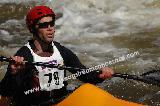
I was happy with my own race. Finished 3rd among kayaks and 7th overall with a time of 2:04.54. Based on my goal of a top 3 finish (among kayakers) and a time under 2:15, I had a lot to feel good about. I lost time on the portages (draining isssues, bow stuck in the trees, stern stuck in the spectator rope, paddle stuck in the stern) and handled the whitewater more tenatively than I will next time. In retrospect, it was only the 4th time I had paddled the Ruahine Swallow (or anything of similarly slender) in whitewater and maybe only the third time using a wing paddle in whitewater -- so I had reason to be tentative.
Started well but not too fast, felt strong over the first 10 miles of mostly flatwater, portaged Six Mile Falls, then survived the sections of standing waves, the portages (thought those were supposed to be much easier with a 30 lb. rather than a 60 lb. boat), the rapids at Shopping Cart, and even the 3 - 4 foot standing waves in the Bangor canal just short of the finish. No lie -- just as the quote in the newspaper article says, the canal may have been the most challenging section of the river for those who finished at around 11:00 AM (approximately mid-tide). By noon, an hour later, the standing waves in the canal had calmed down considerably. The 6 mile section south of Six Mile Falls was notable for it's absence of rocks or other obstructions, but interspersed with gleaming white fields of standing waves (I'll be seeing them in my dreams for weeks). You just had to take a deep breath and pound down through.
Next year, I'll aim to trust the boat more, crash the whitewater with more gusto, and be more efficient on the portages.
Theories on why canoes did so well in this years race:1. the absence of kayakers Kenny Cushman and Jeff Sands (among others)
2. multi-person craft may have had an advantage in maintaining their momentum and pushing through the sections of standing waves
3. just plain good paddling! (I am in awe of anyone who can go that fast in a canoe).
4. take-outs at portages were muddy, slippery, steep -- maybe easier to handle with a 2-person canoe.
5. paddling Six-Mile Falls? All of the first 3 kayaks portaged it. Not sure about the canoes.
Look out next year canoeists! I'll be gunning for ya!
 --Image from rootsweb.com